Posted on 15 June 2010 by
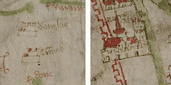
We are having a very exciting time here in Oxford. I eventually realised that the map is the work of at least two scribes. The place names in Scotland are in pale brown ink, and the icons of towns and rivers do not have black outlines. The rivers and coastlines south of Hadrian's Wall have been all traced in black ink, the icons have also been traced and more decorative detail added. Very
 many place-names south of Hadrian's Wall have also been overwritten in darker ink, similar to the one used for pictures and presumably at the same time. In his gazetteer, Parsons had mentioned overwriting, but he either did not realise how extensive it was or did not make it clear in his book. The revision is absolutely impossible to see on the facsimile with which most scholars have recently worked. It does not show the difference in the colour of the inks in the text or on the icons, and does not really allow one to see overwriting. The difference between the two hands can be clearly seen in the two names of Lewes (though the original one is poorly visible on the facsimile). So far all scholars have believed that the map is largely in the same hand (with a few exceptions). Now we have to date the two hands separately: the original hand dating from the third quarter of the 14th century, and the reviser's hand being later in the 15th century. Of course, these initial observations will require further consideration over the coming months, but already they clearly demonstrate how important and overdue such a systematic palaeographical study of the Gough Map is, and what can be gained from it.
